Rainforest to Rockies: A BC Road Trip

Launched in September 2025 the Rainforest to Rockies route through British Columbia is designed to take in some this Canadian province’s most spectacular and diverse scenery. Having spent several days travelling along this route it also serves as an excellent taster to the Canadian wilderness and a tempting menu from which to choose places I’d be very keen on returning to.

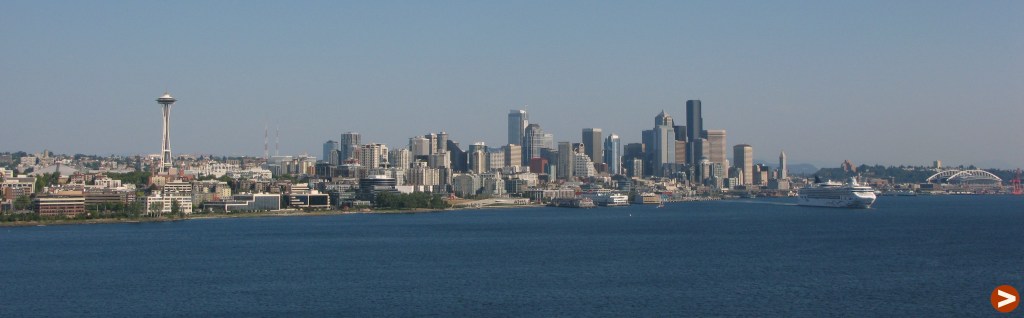
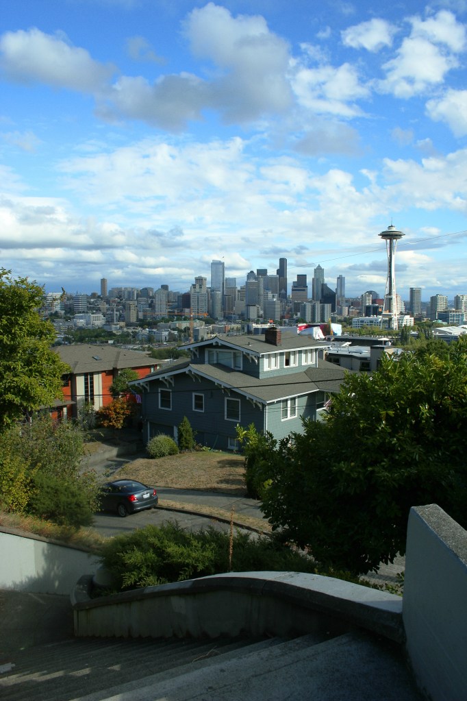
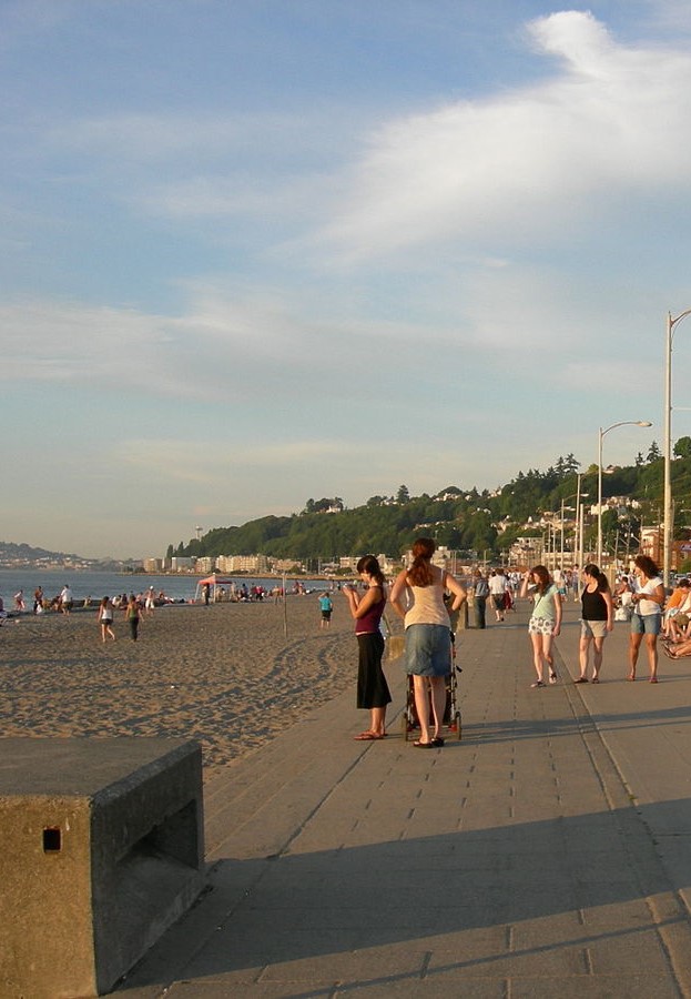
Vancouver is the starting point of this route, convenient for its international airport where 42 airlines fly to 121 destinations worldwide. The city’s coastal location is its main asset and I warded off jetlag with a sunny evening walk along the seawall to Stanley Park. The harbour has been cleaned up since I was last here 17 years ago and I was glad to see a seal frolicking in the shallows. Gastown – Vancouver’s historic heart – also feels buzzier than it did before.

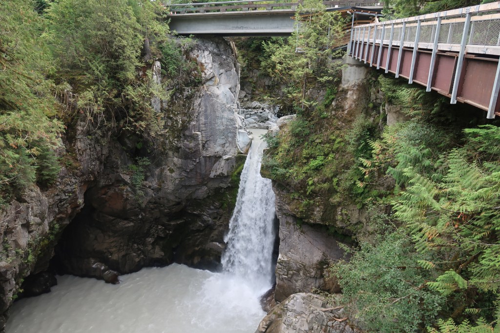
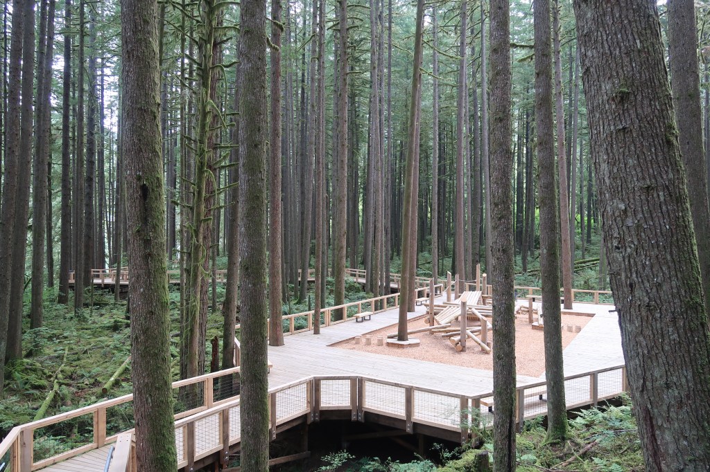
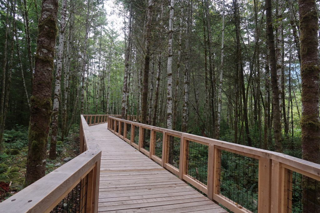
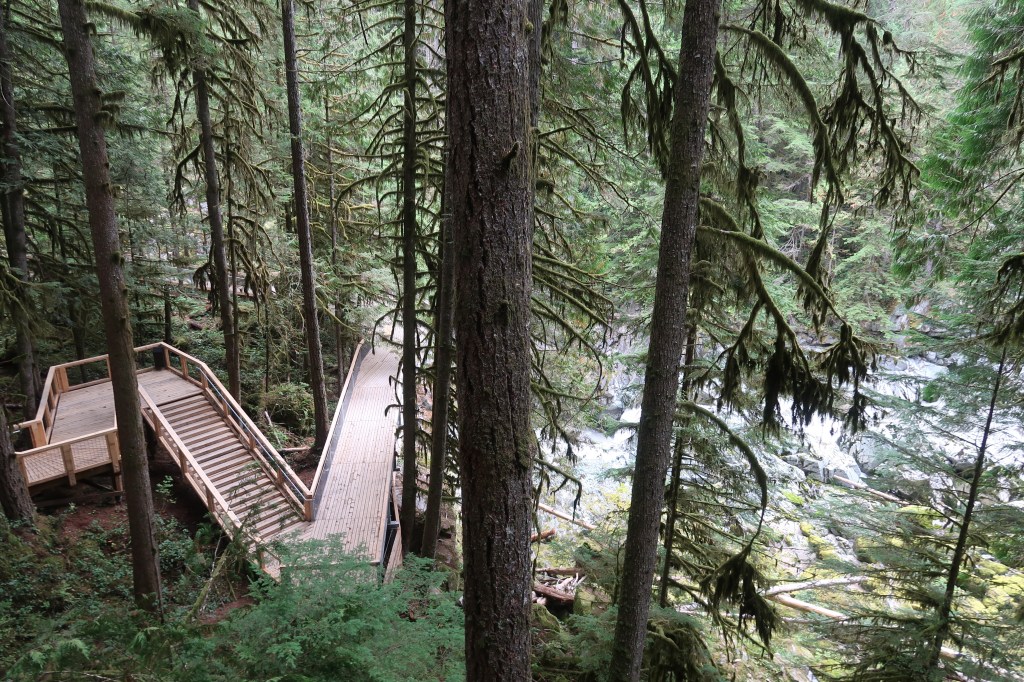
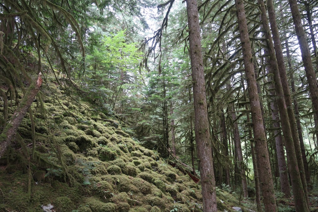
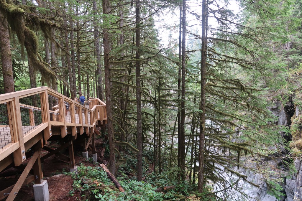
In British Columbia the ‘road’ part of ‘road trip’ is so often a highlight, the Sea to Sky Highway spectacularly proving this point as it winds away from Vancouver, along cliffs above the islands of Howe Sound, past Sḵwx̱wú7mesh (Squamish) and the newly-installed boardwalks of Squamish Canyon. The Canyon is well worth a stop and the $44 entry will feel like a bargain as you walk along the elevated wooden path that weaves through second-growth forest (that would otherwise have been used for logging) all the way to dramatic Mamquam Falls.

Having left the sea behind it felt like we were truly in the sky when we reached Whistler, which sits at 670m and is surrounded by the Coast Mountains. I like this town, a lot. It ticks my boxes of: cute pedestrianised centre ✔️, scenic walks directly from town ✔️, and; easy access to the mountains ✔️. After enjoying quite possibly the best croque madame I’m ever likely to have at Lorette Brasserie I was ready for the walk through the forest to Lost Lake. OK, so this is an easy walk that didn’t justify the size of the breakfast, and the trails are well-marked and easy to follow. They mostly lead to the lake, which is a relatively warm body of water (well it was in mid-September, anyway) where people could swim and sunbathe surrounded by trees and mountains.

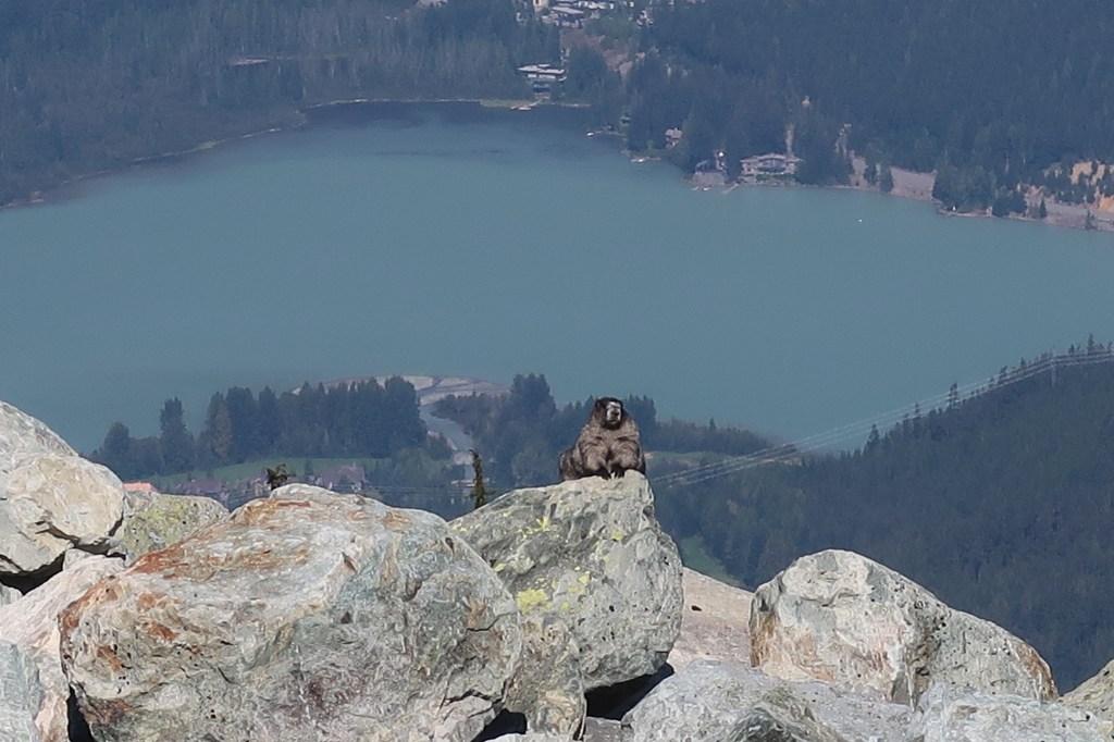
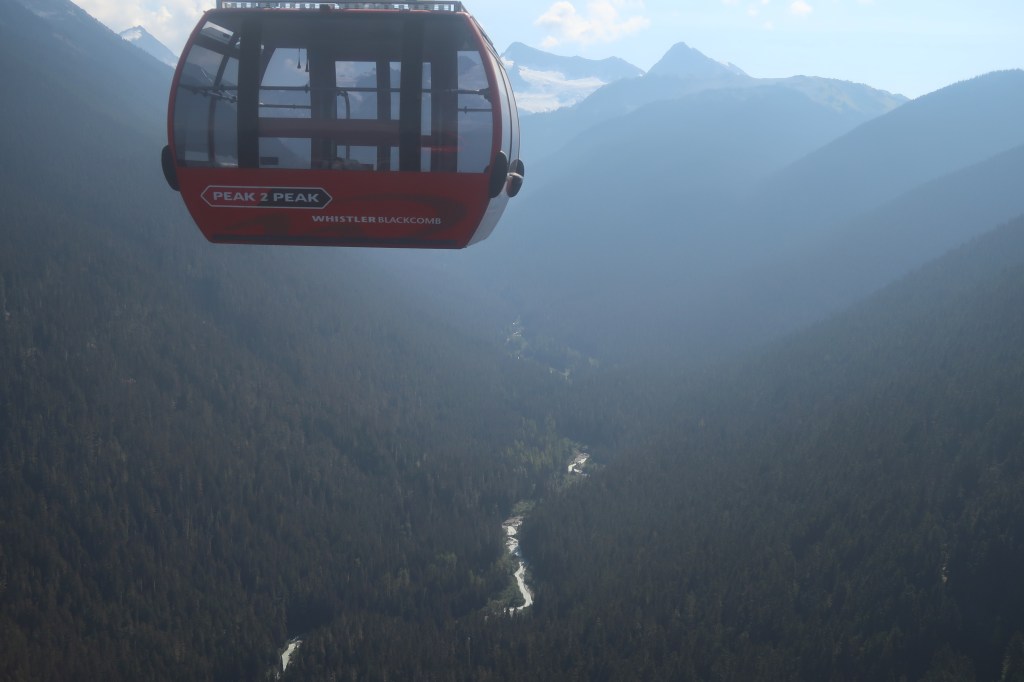
I was itching to get into those mountains, an itch that was easily scratched thanks to the conveniently-located Blackcomb gondola which whisked me (and, in winter, thousands of lucky skiers) up above Big Easy Terrain Park where we saw some plump marmots and learned that Whistler is named after the sound these squeaky creatures make. Next: the world’s longest unsupported gondola span. The PEAK 2 PEAK gondola is engineering at its most thrilling and allows for 11 minutes of peaceful and lofty contemplation of the dramatic landscape.

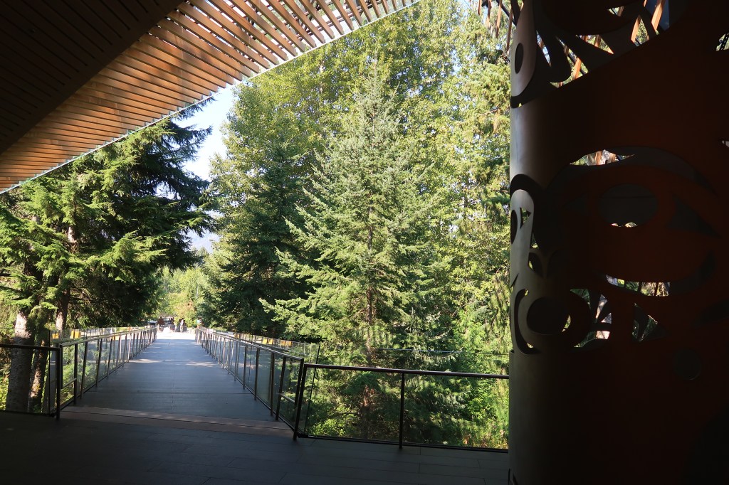
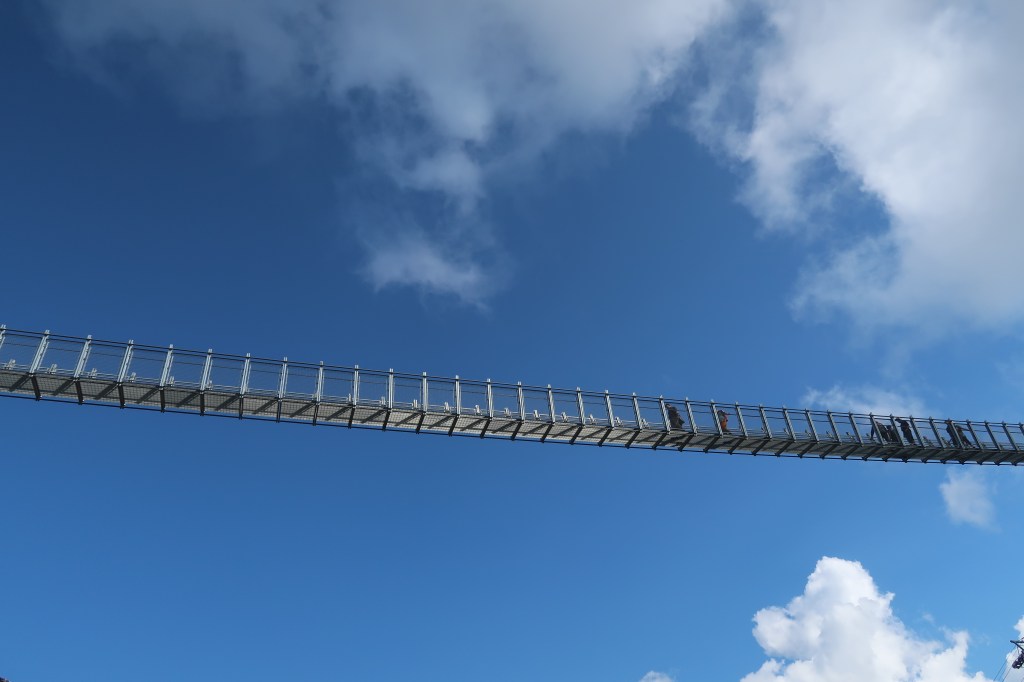
Those contemplations were about to get even loftier for, after arriving on Whistler Mountain, we boarded the Peak Express chairlift to the Cloudraker Skybridge, a wobbly suspension bridge that leads to Raven’s Eye Lookout. This walkway juts out over a high cliff and has yet more incredible views.

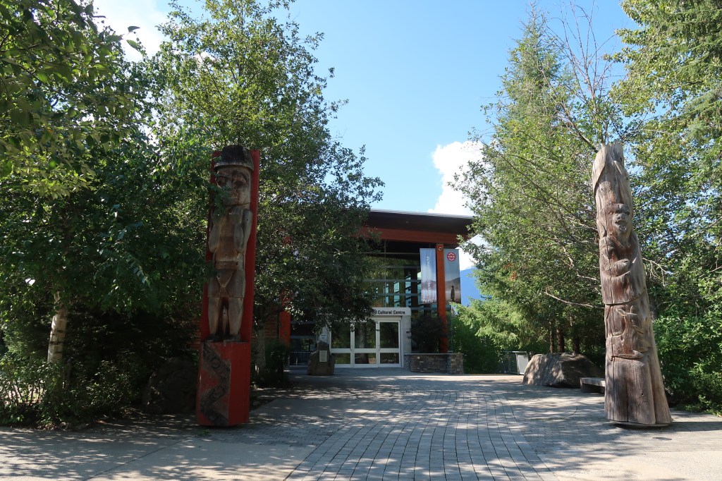
Over the road from my hotel the Squamish Lil’wat Cultural Centre shares the stories, cuisine, history and culture of the Sḵwx̱wú7mesh (Squamish) and Lil̓wat7úl (Lil’wat) nations who share the land on which Whistler is located. Admission is just $25 and includes guided tours, the centre’s Thunderbird Cafe serves up First Nations-inspired cuisine. I was deeply impressed by the range of exhibits, the simplicity of the information boards and the imaginative way in which the building was designed.

Just when I thought the roads here couldn’t get any more scenic we took to the Duffey Lake Road, which winds 129km from Whistler to Lilooet. Our Rainforest to Rockies route then well and truly left the rainforest behind when we dropped down from those Coastal Mountains and down into the arid Thompson Valley.

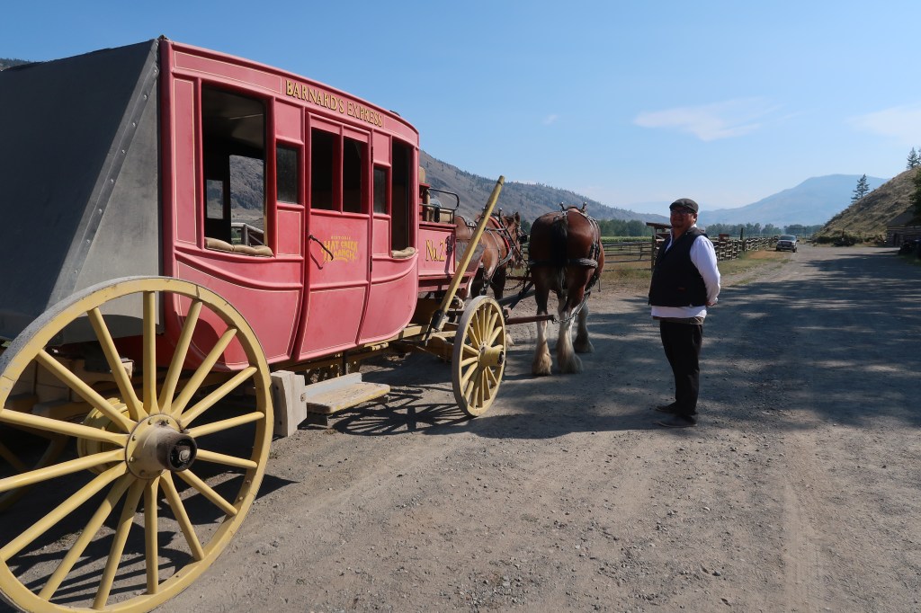
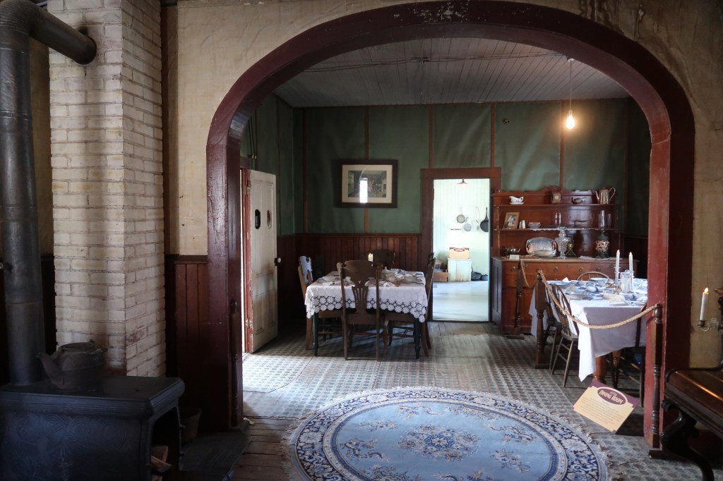
It took travellers 10 days to travel the length of the Cariboo Road during the 1800s Gold Rush, we got to Hat Creek Ranch in just a few hours. The historic buildings here once accommodated those weary and hopeful travellers, considering some date back to 1860 they’re in such good condition that you can still see the original wallpaper. Here, too, is an Indigenous Interpretation Site (complete with a pit house) as well as an excellent value restaurant.

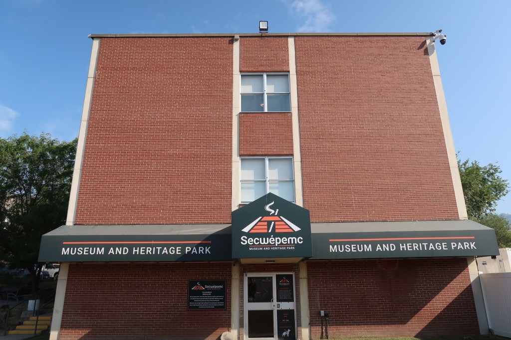
On to Kamloops, a popular stop on the famous Rocky Mountaineer rail route. Within the Kamloops city limits Kenna Cartwright Park is a vast hilly area of hiking and biking trails with long views over the city and Thompson river. In the other direction the Privato Vineyard and Winery provides the more sedate experience of wine tasting amid long ribbons of vines. A far more sobering experience was seeing the former Kamloops Indian residential school on Tk’emlúps te Secwépemc First Nation territory. Here, too, is the Secwépemc Museum showcasing the history of this First Nations people. If you can I recommend arranging for a guide to show you around the exhibits.

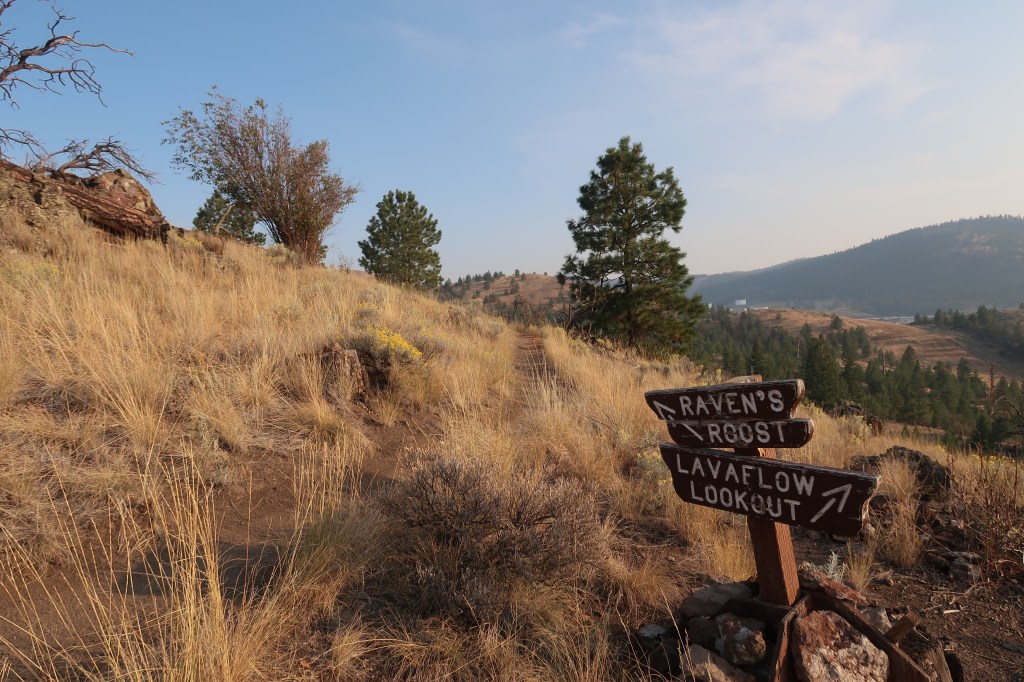
A 90-minute drive north along BC-5 will bring you to Clearwater. The fur trtade brought settlers to this Chilcotin territory, when the railway arrived in 1914 it was mining and logging which brough prosperity and growth. There’s been a steady growth in the population (to just under 2,500 people) but because this is a sprawling town it seems as though the wilderness is right there with you. To actually get into the wilderness isn’t that difficult, with the entrance to Wells Gray Provincial Park just minutes away.

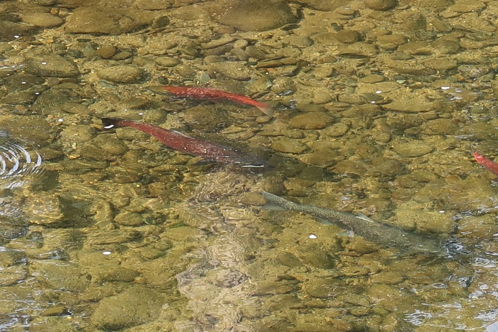
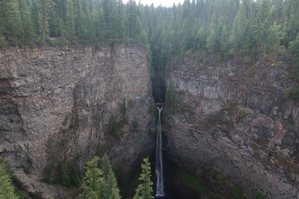
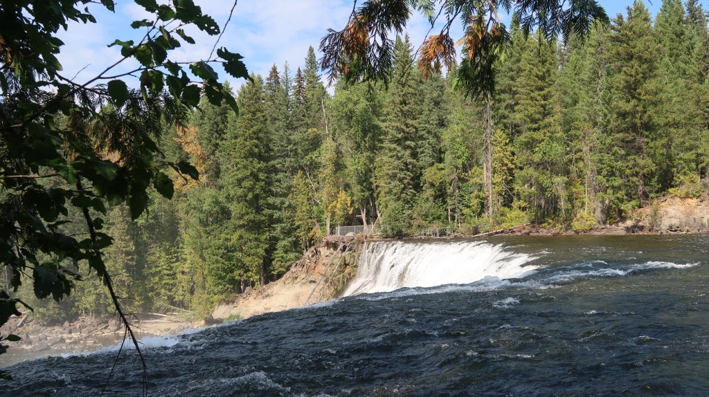
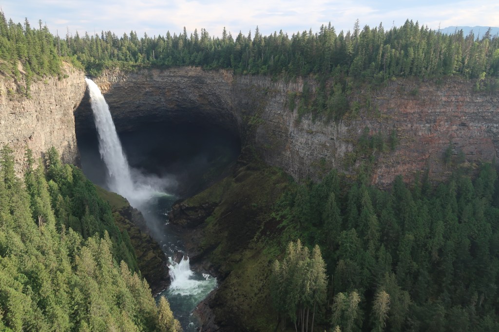
There’s a rich choice of waterfalls in this park, from the wide Dawson Falls to the immense Helmcken Falls. The latter are the fourth highest falls in Canada, tumbling 141 metres into a steep-sided canyon which is topped with green forests. Viewing platforms help visitors stand in awe at these watery wonders and the excellent BC Backcountry Adventures help more intrepid visitors go deeper into the wild.

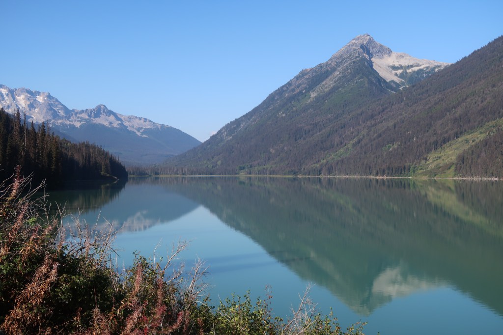
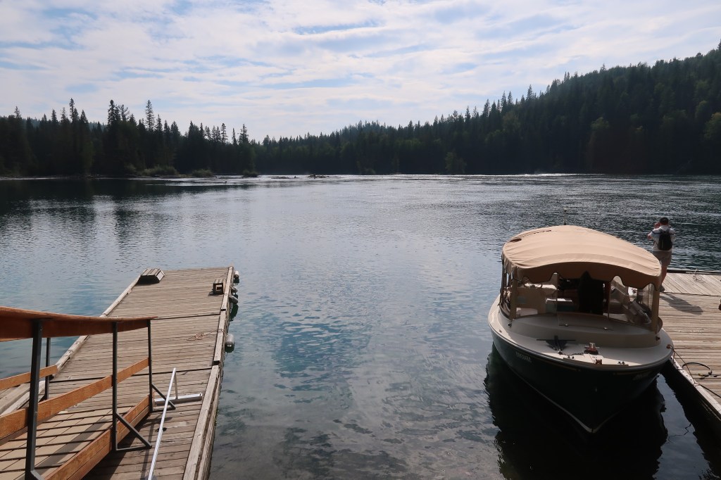
More watery joys await, further down the road (which becomes an unpaved tracks) into Wells Gray. That track/road ends at Clearwater Lake where a large wood cabin houses the Osprey Cafe (named after nearby Osprey Falls) and the rental office of Clearwater Lake Tours. You can hire kayaks and canoes from them but I took an electric boat tour over over the appropriately-named lake.

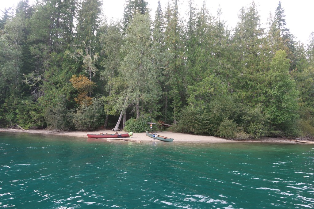
Serene doesn’t begin to describe Clearwater Lake and the individual beach campsites all around it. You’ll need a canoe or kayak to get to those sites, you can also portage your craft into Azure Lake for an even more remote camping experience.

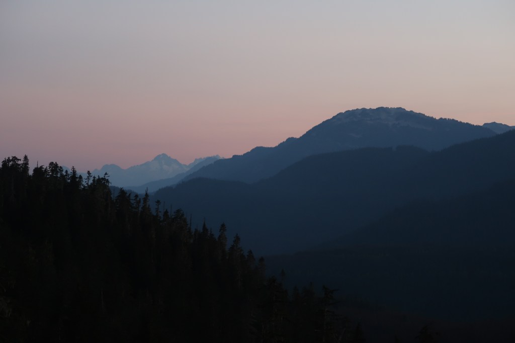
I had to drag myself away from Wells Gray Provincial Park and the Monashee Mountains for the Rockies awaited. Not just any Rockies, either; the tallest mountain in the Rockies.

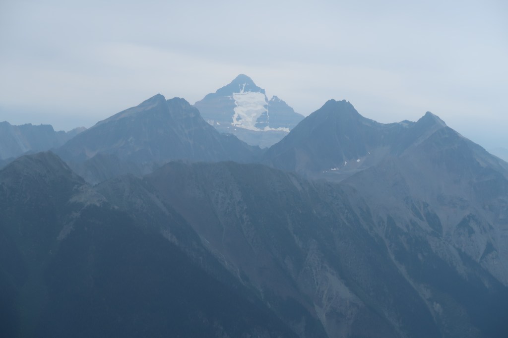
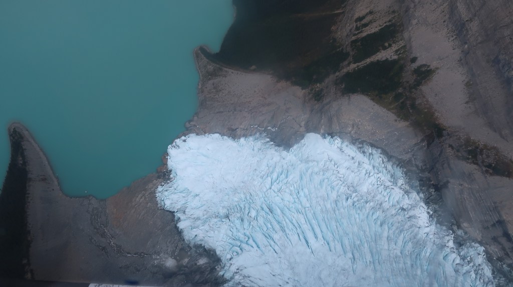
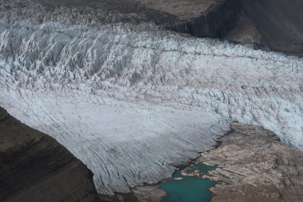
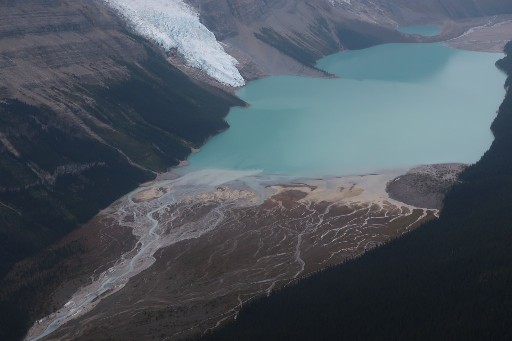
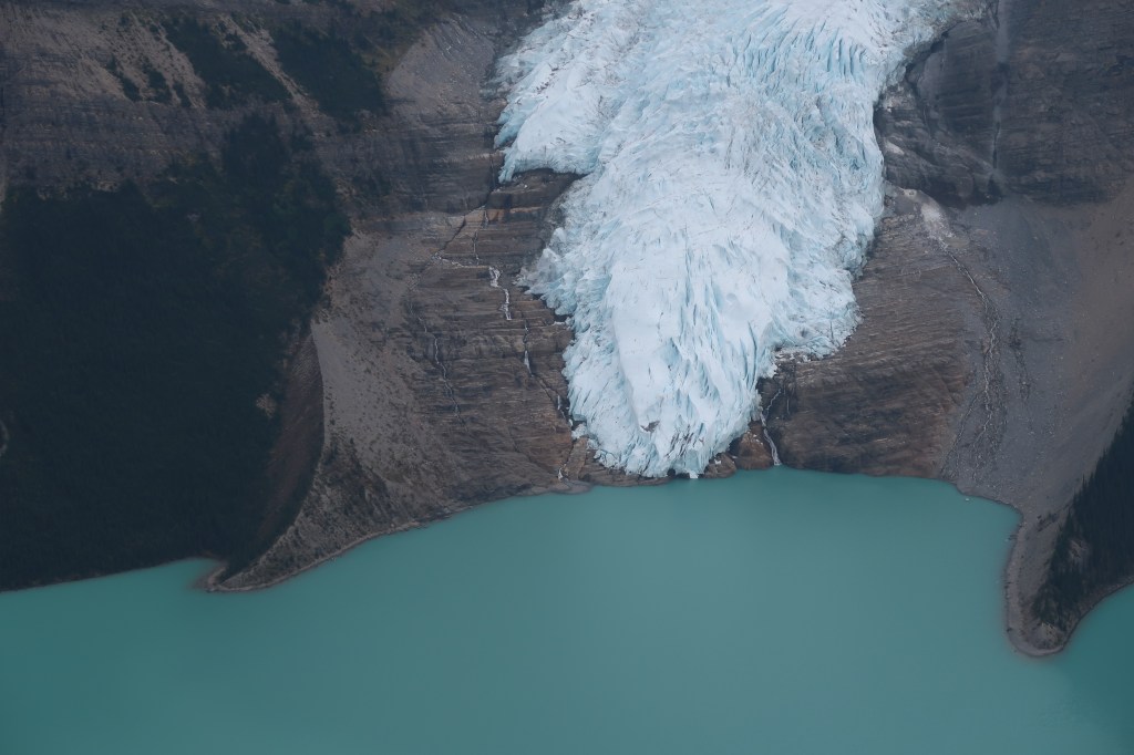
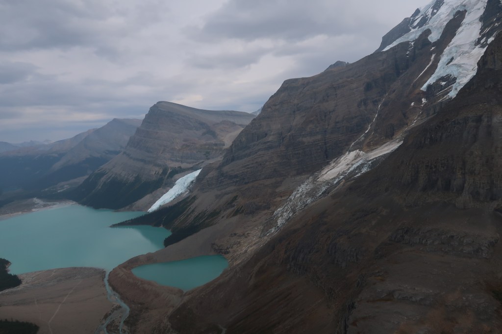
I’m not a climber and so it’s rare for me to see the top of a tall mountain. Thanks, though, to Robson Helimagic I was able to soar close to the top of 3,954m Mount Robson on a flightseeing tour that was 45 minutes of sheer awesomeness. Even at the flying height of the helicopter the mountains in and around Mount Robson Provincial Park looked immense.

The highlight of this helicopter tour was being able to peer over – and int0 – long tongues of glaciers where blue ice appeared among the crevasses. Below the glaciers were large lakes and forests and the promise of some epic hikes. Yet another place I must return to.

My journey, though, would go beyond those mountains and in to Alberta. This Rainforest to Rockies route had ticked all of my many boxes when it comes to adventure, the great outdoors and a large dose of culture, too. There are few routes I’ve been on where the scenery is quite so consistently spectacular.

Where I stayed

Vancouver: Fairmont Waterfront
Whistler: Fairmont Chateau Whistler
Kamloops: Sandman Signature Kamloops Hotel
Clearwater: Quality Inn & Suites

Caledonian Sleeper vs Night Riviera

Comparing the UK’s 2 sleeper train services in 14 different categories

Caledonian Sleeper vs Night Riviera
The Night Riviera sleeper train in London’s Paddington Station

The UK has two sleeper train services: the Caledonian Sleeper from London Euston to Scotland, and the Night Riviera from London Paddington to Cornwall. How do they compare for their basic cabins (aka Classic Room on Caledonian Sleeper)?

Caledonian Sleeper (CS)Night Riviera (NR)Winner
Single price for 2 adults with railcard£275£232.40NR
Website user experienceConfusing info about Room Supplements, buttons hard to see, lots of steps to get to orderNot immediately obvious what the options are for the service selectedNR
Accepts railcards?NoYesNR
Journey time7h 33m8h 9m
BikesFreeFree
Dogs£30£30
Choice Caledonian Double, Club Room, Classic Room, seatCabin, seatCS
Breakfast includedHot drink and oat barHot drink, choice of bacon roll, fruit, croissant, cereal or porridgeNR
Lounge accessYes, in Dundee, Leuchars and Perth (other lounges available for more expensive cabin types)Free access to First Class lounge (with hot and cold drinks, snacks, fruit, pastries and shower access) in Paddington, Penzance, TruroNR
Lower bunk size190x63cm193x62cmNR
WashbasinYes, but no coverYes, with coverNR
Amenity packSoap, towel, eye mask, ear plugsSoap, towelCS
Cabin techReading lights, cabin lights, temperature control, UK plug sockets, USB ports, host call buttonReading lights, cabin lights, temperature control, UK plug sockets, USB ports, room service button
WiFiFreeFree
StorageUnder lower bunkUnder lower bunk, tiny cupboardNR
On-board diningDining car with full menuSnacks and light bitesCS
Lounge/barDining car is also bar, priority access for Club Room and Caledonian DoubleFully stocked bar, free snacks and non-alcoholic hot and cold drinks NR
ComfortExcellent mattress, but bumps and shunts during night (stops at 00:10, 05:07, 06:15)Smooth journey (stops at 00:49, 02:37, 04:11, 04:32, 05:11, 06:12, 06:26, 06:33, 06:41, 06:49, 07:07) bunk ladder folds easily away for more spacious seatingNR
Dis/embarkationRooms available up to 1hr 20m before departure (they wouldn’t actually let me on until 5 mins before) and 30m after arrival. No lounge for basic cabinsLounge available 2h 45m before departure, from Penzance to Paddington the train arrives at 05:04 but guests can stay on until 06:45 (and then use the lounge)NR

TOTALS
Caledonian Sleeper: 3
Night Riviera: 11

Watch a video of a Night Riviera sleeper train journey between Truro and London Paddington:

Europe’s free public transport revolution

Free public transport in Europe is more common than you may think

Free public transport in Europe
One of Luxembourg’s free buses

When Germany created a €9 ticket for unlimited train travel in June, July and August almost 52 million were sold, with a reduction of 1.8 million tons of CO2. The increase in free public transport in Europe is most apparent in Luxembourg hasseen less busy rush hours on the roads, although overall traffic on the roads has increased (no data available yet for 2022).

Several countries in Europe have now either experimented with, are about to launch, or have permanently introduced free public transport. Whether this is to ease the pain of increased costs or to help the environment, it’s good news for those travelling to these countries.

FREE train tickets in Spain

Spain is currently offering free commuter (Cercanias/Rodalies) and medium-length journeys of less than 300km/186 miles (Media Distancia) until 31 December – see details on the right on how to get your ticket

getting your free spain train ticket

1. Register with Renfe
2. Subscribe for a multi-trip pass and pay a deposit of €10-€20
3. Take at least 16 journeys before 31 December

Although designed to assist commuters during the cost of living crisis, tourists can also take advantage if they’re taking numerous short hops by train. For travel in and between Asturias, Bilbao, Cadiz, Madrid, Malaga, Murcia/Alicante, Santander, San Sebastian, Seville and Zaragoza you’ll need the Cercania pass, for Valencia and Catalonia you’ll need the Rodalies pass. Longer distance trains (Avant) are also discounted by 50% until 31 December.

FREE buses in Malta

From October public transport buses in Malta will be free (details on how to get free tickets on the right), meaing you can travel from Valletta to Mdina, San Lawrenz to Xlendi…or any other part of Malta and Gozo for €0.

GETTING YOUR FREE MALTA BUS TICKETS

1. Register for a tallinja card (you’ll need your passport number)
2. Scan your card when you board the bus

Malta has a population of 500,000 and yet there are over 400,000 cars on its roads. Encouraging even more people onto its extensive bus routes is therefore vital, and is of course great news for visitors for whom, apart from hire cars and boat taxis, buses are the main way of seeing the islands. This map shows you exactly where you can go and which buses to take.

FREE public transport in Luxembourg

No information box needed here; all you need to do in order to take free public transport in Luxembourg is step aboard. Trains, trams and buses are all free no matter where you go in the country. For an idea of how best to use this amazing resource, have a read about my recent trip to this country at the heart of Europe.

FREE public transport in European cities

It’s not just countries which are offering free public transport, there are many cities in Europe where you can travel for nothing, including these tourist favourites:

Explore diverse Seattle neighbourhoods

Get to know 8 very different Seattle neighbourhoods, and how to visit each one

Seattle neighbourhoods
Seattle’s iconic skyline

Seattle neighbourhoods are diverse and characterful and, thanks to the city’s busy cruise terminals and proximity to stupendous national parks, they’re becoming ever more popular with tourists. Having taken dozens of business and leisure trips to the Emerald City over the years, I’ve become familiar with neighbourhoods away from Downtown, how they are changing as a result of the influx of wealth, and how each of them contributes to such an exciting city.

Queen Anne

Seattle neighbourhoods: Queen Anne
View from Queen Anne

Home to Frasier, this wealthy and historic neighbourhood, named after the Queen Anne mansions found here, has some of the best views of the city, particularly from Kerry Park. At the top of the hill on which it’s situated there’s a cute high street with upscale coffee bars and organic food retailers. Yep, it’s that sort of place. On the other side of the hill large houses overlook the Union Canal.

🚶

It’s a 40-minute walk from Pike Place Market to Kerry Park, via Belltown. Directions here.

🚌

Take bus #2 from Downtown. Details here.

Capitol Hill

Seattle neighbourhoods: Capitol Hill
Characterful Capitol Hill

If you don’t like to confirm to societal norms you’re gonna love Capitol Hill. Here are coffee shops with live music, LGTBQ+-friendly bars and clubs, many microbreweries, and more than a few tattoo parlours. Named in the hope that Washington’s capital would be located here (it’s actually Olympia), this neighbourhood often hosts festivals and protests, and has some gorgeous old houses .

🚶

A steep walk 35-minute up from Pike Place Market. Directions here.

🚈

Capitol Hill’s Link light rail connects the neighbourhood to Downtown (Westlake) and Tacoma Airport. Details here.

South Lake Union

Seattle neighbourhoods: South Lake Union
Burgeoning SLU

The engine of Seattle’s recent growth, South Lake Union is an Amazon neighbourhood. Locals have long been priced out of the area and it’s now home to wealthy tech workers and shiny new buildings. Thankfully visitors can still access Lake Union and kayak, lounge at the water’s edge, watch float planes take off and land, or visit the excellent Steamer Virginia V and Museum of History and Industry.

🚶

An easy 25-minute walk to Lake Union Park from Pike Place Market. Directions here.

🚌

Take bus 40 from Fremont or Downtown, or rapid line C Line from Downtown to Westlake Ave N & Mercer St.

Ballard

Seattle neighbourhoods: Ballard
Ballard’s historic buildings

Oh-so-trendy Ballard sits towards the city’s northern edge and is where to come if you like small live music venues. The Duwamish favoured this area for the salmon fishing, as did later Scandinavian settlers. My favourite thing to do here is visit the Hiram M. Chittenden Locks where you can watch, for free, salmon swimming to spawning areas, as well as large vessels passing along the Washington Ship Canal.

🚶

I’ve walked from Downtown to Ballard. It’s a long way – about 2 hours from Pike Place Market to the locks, albeit via lovely Queen Anne.

🚌

Bus 29 will take you all the way from Downtown to the locks (stop NW 54th St & 30th Ave NW). Details here.

Fremont

Seattle neighbourhoods: Fremont
By Wonderlane, Flickr

Fremont used to be where locals could find affordable accommodation, until Amazon…well, you know the rest. This neighbourhood does, however, retain heaps of character, evidenced in its immense troll, quirky street art and Summer Solstice Parade & Pageant. If you must do one thing in Seattle, then do a tour of the Theo chocolate factory, and try ALL the samples. Yum.

🚶

Wander along the edge of Lake Union, or through the lovely Queen Anne environs. It’s about an hour from Pike Place Market. Directions here.

🚌

Bus 40 and bus 62 are your best options to get from Downtown to the Fremont Ave N & N 34th St stop.

Bellevue

Bellevue, Seattle
Bellevue & Cascade Mountains

Ah Bellevue. Shiny, shiny Bellevue. As suggested by the name, you can get some beautiful views from this neighbourhood (particularly from Chism Beach Park), which is across Lake Washington from Downtown. Home to perfect malls, upmarket eateries and corporate skyscrapers, Bellevue is a great place to find good value accommodation and top-notch cuisine.

🚌

Your most efficient bus route to Downtown is #550. Just don’t be tempted to walk…it’s too far.

🚈

In 2023 you’ll be able to ride the Link light rail allll the way from Downtown (Westlake) and Tacoma Airport to Bellevue. Details here.

Belltown

Bell Town, Seattle
Belltown from the Space Needle

Recently renovated Belltown is on the edge of both Downtown and Puget Sound. It has some really lovely bars, plenty of great dining options and a thriving nightlife. You’ll find boutique accommodation here, as well as the 9 acre Olympic Sculpture Park. I love the old red brick warehouses and walking along Centennial Park, where trains travel to Canada and California. You’ll probably pass through Belltown on your way to the Space Needle.

🚶

An easy and lovely 15-minute stroll along the waterfront from Pike Place Market to the sculpture park. See directions.

🚌

Take bus 29 to Downtown, Ballard locks or Queen Anne from 1st Ave & Broad St.

West Seattle

West Seattle
Alki Beach

And now for something slightly different. West Seattle feels far removed from the frenzy of Pike Place Market, and has perhaps one of the best beaches in the area; Alki Beach. From this wealthy neighbourhood you can enjoy relaxed beachside dining, as well as views of the city, Puget Sound, and the grand Olympic Mountains. Alki Point is believed to be where the Denny party first settled, and the Log House Museum is bursting with Seattle history.

⛴️

Pier 50 is a 20-minute walk from Pike Place Market. From the pier you can take a ferry to West Seattle Pier, and then either bus 775 or walk 45 minutes to Alki Beach.


A note about the Duwamish

Before all these neighbourhoods grew out from the Denny party’s initial settlement at Alki Point, the areas they now occupy were inhabited by Native Americans for at least 4,000 years. In fact, Seattle is named after the tribe’s leader, Chief Si’ahl. The Duwamish Tribe is not recognised by the US government, due to the government not honouring the Point Elliott Treaty, although a May 2022 appeal hopes to change that.

Duwamish members are involved in United Indians of All Tribes, and I strongly encourage you to visit their cultural centre in gorgeous Discovery Park, as well as their gift shops (one of which is in SeaTac Airport). The Duwamish Longhouse and Cultural Center also makes for a fascinating visit, and is located just southeast of West Seattle – take bus 21 from Downtown and then walk 20 minutes.

The Best of the New Forest

My local’s guide to the best of the New Forest

Best of the New Forest: a low sun shines through trees, a white pony looks to camera
A New Forest pony near Brockenhurst

I’ve been fortunate to be well acquainted with the New Forest National Park in southern England for all of my life. It’s a place that feels like home to me, where I’m familiar with the tracks and the trees and the lifecycles of its animals. Here you’ll find the Three Bs – three key places which, if you visit them, will ensure that you’ve seen the best of the New Forest.

Beaulieu

Named after the ruined abbey which was founded by French monks, Beaulieu is a small village blessed with cute cottages and with a large palace just the other side of a bucolic river. The palace is the home of Lord Montagu, and can be visited by anyone going to the National Motor Museum (full of motoring exhibits plus loads of fun rides for kids).

TOP TIP: Take the easy 7.5km walk along the Beaulieu River to Buckler’s Hard, where shipbuilding thrived in the 18th century

Brockenhurst

There’s much more to write about Brockenhurst. Most importantly; it’s the easiest place to reach in the New Forest thanks to its direct and frequent train connections to London (1h30m from Waterloo, at least two departures/hour). When you arrive you have the choice of hiring a bicycle, embarking on a horse riding adventure, chilling out at a spa or choosing from one of the many excellent hikes.

The Best of the New Forest: leafless trees next reflected in water
Trees and wetland near Lyndhurst

I’ll make a separate post about hikes from Brockenhurst, because there are quite a few and, because they deviate from the beaten path, I’ll need to include maps. But you should know that there are hundreds of miles of tracks and paths which lead to or around Brockenhurst, going deep into the woods, over marshes, past plains full of deer, over rivers, along disused railway tracks…it really is an amazing place for hikers.

As for bikers, there are a few places to hire cycles in Brockenhurst and the national park authority has mapped out a good range of routes from the village. Because the New Forest is relatively flat the going is easy, but it can be easy to get lost so do bring a map.

Brockenhurst has been described as the New Forest version of Monopoly’s Mayfair, thanks to the high prices of property here which reflects its place as the very best of the New Forest. With this fairly recent influx of wealth has come fine dining options such as The Pig on the edge of the village, plus a wine bar and upmarket hotels. For spa lovers there’s a choice of either Carey’s Manor or the New Park Manor. If you really want to splurge then Rhinefield House is just a few minutes’ drive from the centre and located in the depths of the forest.

Burley

Some believe that witchcraft has existed in the New Forest for many centuries. What we do know is that, in the 1950s, a White Witch named Sybil Leek lived in the cute village of Burley, which is nestled in a little valley surrounded by woods and plains. Walking in the depths of the New Forest you can sometimes see markings associated with witchcraft, but Burley is much more obvious about this association.

A Coven Of Witches is a delightful shop named by Leek, and it’s where you come for crystals, candles and other such paraphernalia. Burley’s other shops and tea rooms are sure to charm, and if you want to splurge then Burley Manor is a good place for afternoon tea with views across a field of deer. If you’re travelling by public transport then the New Forest Tour bus may be of interest.

A railway line once stretched from Brockenhurst to Bournemouth via Burley. Nicknamed ‘Castleman’s Corkscrew’ (after a railway planner, plus the shape the tracks take), it was usurped by the line you may have arrived by, and so it’s now abandoned. This is good news for cyclists and walkers who can follow the disused railway from Burley to Brockenhurst. It’s a very picturesque route and there’s even a tearoom in the old railway station halfway along.


Getting to the New Forest

🚅

Trains from stations including Manchester, London, Bournemouth and Lymington (for the Isle of Wight) to Brockenhurst.

🚌

Cheap coaches are available from London via Southampton, and also from Bournemouth. Local buses also to Lyndhurst and Southampton.

🚗

Driving distance from London is around 90 miles (150km), mostly along the M3 and M27. Maximum speed in the New Forest is 40mph. Be aware that animals (ponies, cows, donkeys etc) wander across roads so please drive carefully.

The New Forest’s best accommodation

£

YHA New Forest
Located in Burley with decent bunks, good-sized kitchens and a choice of cosy communal areas

££

Premier Inn Hordle
Not the prettiest village but well-located between the Forest and the coast

£££

Balmer Lawn Hotel, Brockenhurst
A short walk into Brockenhurst, views across the open forest, lovely spa

££££

Montagu Arms, Beaulieu
Beautiful Beaulieu’s only accommodation offers grand rooms and use of the spa at Carey’s Manor

££££
£

Lime Wood, Lyndhurst
Set in the heart of the forest, this Regency-era estate is the ultimate in tasteful luxury (yes, there’s a spa)


PLEASE NOTE: A lot of time has gone in to researching this Best of the New Forest post. Some of the links above are to my affiliates’ sites and any purchases made via these links will help me to keep this blog going. The use of these links has not in any way influenced the recommendations I have made.

How to navigate a city

7 tips to help you navigate a city

How to navigate a city: aerial view of Quito, Ecuador
Quito, Ecuador

“Not all those who wander are lost” (JRR Tolkein), but if you find yourself more lost than wandering here are some useful tips on how to navigate a city which have served me well in the past:

Get high

How to navigate a city: skyscraper icon

Something I try to do early on in a city visit is get to a high point, such as a hill or observation platform. This helps me to figure out the layout of the city and to commit to memory where key landmarks are. Note that this isn’t particularly useful if you don’t have a great memory, or if you’re in a particularly labyrinthine city such as Venice (where getting lost is part of the fun anyway).

Get down

If you’re in a city with river/lake/sea frontage then, if the streets are sufficiently steep, you can make an educated guess that they will generally point down towards that waterfront.

Pier icon

Ignore subway maps

Subway map icon

Although subway maps can be useful in figuring out which line to take where (although some aren’t all that useful…New York), they are rarely an accurate reflection of how a city is laid out. Although the London Tube map shows you the different stations on a particular line, the distances and locations of those stations are in no way mirroring what’s happening above ground.

Rush hour roulette

During rush hours see if you can figure out where the crowds are heading. Chances are they’re all aiming for the nearest bus stop, train station or subway. If you’re lost, get swept up in the crowd and no doubt they will guide you to where you want to be.

Icon of group of people in front of city

Seek god

How to navigate a city: church icon

Did you know that the main entrance to a church or cathedral faces west, with the apse and altar facing east? This may not be true of some Christian buildings, but this knowledge can help you navigate, if you know where on the compass you want to be heading.

Go wild

Wilderness survival tips can apply to city navigation too. Seek out the sun or moon and figure out where they’re rising or setting. Unless the wind changes direction, look up to the clouds to see where they’re flowing: if you don’t want to go around in circles then keep following the direction of the clouds.

Sun behind clouds icon

Ask

People talking icon

If you feel safe enough doing so then simply ask where the nearest station is, or how to get to a particular street. It can be useful learning a few local words for asking directions, and if you don’t understand the answer people can at least point you the right way.

Source of Thames hike

A short picture journey following my hike from the source of the Thames to Oxford

A footbridge over the Thames

In need of a mild adventure, I booked a train ticket to Kemble, in the English county of Gloucestershire. At my side was my dog Bounty, in front of me was a 52 mile walk along the Thames, from its source to Oxford.

Day 1: Kemble to Cricklade

My train arrived at 08:39 and we set off straight away for the source of the Thames. 20 minutes later we arrived at the Thames Path, which runs 185.2 miles to the Thames Barrier in London. Our destination was to the right, but we turned left and walked about a mile to the source.

The Thames Source and Bounty

The Thames begins at a remote point beside a forest, and entirely underground. Having reached this point I turned around and retraced my footsteps to the edge of Kemble. All along the way I followed a ditch, I believe that the ditch fills with the Thames during rainier months but when I was there it was empty.

Small pools appeared where the ditch widened. The path was now in a small forest and, when it emerged in a little village, I at last saw the Thames begin to flow. During Day 1 the path passes between a series of lakes and the pretty village of Ashton Keynes. By mid-afternoon I had reached Cricklade.

Day 2: Cricklade to Rushey Lock

Although the forecast rain storms didn’t materialise, today did not begin well. The path downstream from Cricklade was incredibly overgrown and hard to follow. After Castle Eaton, though, things improved considerably.

At Radcot Bridge I stopped at an old pub to re-energise before the final push to Rushey Lock, where I set up camp for the night.

Day 3: Rushey Lock to Farmoor

There are a lot of old stone bridges carrying traffic over this part of the Thames. There are also a lot of attractive footbridges. The path passes through forests, lakes, meadows, and more than a few fields full of cows and sheep. In retrospect, 52 miles in 3 days with 11kg on my back was a bit too much, and I was grateful to hop on a bus to Oxford from Farmoor, and then a train home to London.

My post about the next section of the Thames Path – from Reading to Oxford – can be found here.

Pagan London

Read about some of the sacred Pagan sites in the UK capital

Britain is home to many famous pagan sites, including, of course, Stonehenge. These sacred sites are dotted throughout the land, including London.

Primrose Hill

Druids have been climbing Primrose Hill to mark the equinoxes for 305 years. At the top of the hill, along with breathtaking views of the city, you’ll also find a stone plaque which commemorates the Welsh Druid priest who organised the first ceremony here in 1717. Ley lines – invisible lines demarcate Earth’s ‘energies’ – are believed by some to run under the hill.

Thorney Island

Druids once devised laws on this island, which was between the streams of the River Tyburn. The island disappeared along with the Tyburn, but you can visit the location at Thorney Street, a few blocks west from the Houses of Parliament.

Temple of Mithras

This Roman temple was discovered in 1954 during the construction of a building. It dates back to the mid-3rd century and is dedicated to Mithras, a cult which had feasting as one of its rituals.

London Stone

Although probably originally part of a building (the Roman Governor’s Palace), this ancient stone is shrouded in pagan myth.

Ludgate Hill

A pagan temple stood here until 597. Now all you’ll find there is St Paul’s Cathedral.

Not just your imagination

Close your eyes and imagine Indonesia. When you see this country for yourself you’ll realise that what you pictured is probably pretty accurate. In fact, the reality will likely exceed expectations. 

There’s the well-preserved temples of Borobodur, the alien landscape of Mount Bromo and the perfect, serene rice terraces around Ubud. And then, of course, there are glorious beaches.

Waking up before dawn to see sunrise at Bromo was both exhausting and incredibly rewarding. We only used buses to get about, but the railway on Java seems as though it works well and therefore a good option for travellers. 

For these itineraries I’ve tried to avoid the crowds in Kuta, but there are great luxury, mid-range and budget options available and so, after the idyll of Lombok, it seemed a good and sensible place in which to end this journey. Just a word of warming if taking bemos; hold on tight and prepare to have many conversations with locals.

The bad train which no longer runs

We thought it would be a romantic way to travel – sleeper trains usually are. The journey did actually start off OK, as you’d hope when departing from a station as opulent as the Ottoman-era Haydarpasa. On-board the cabin was as good as you’d expect, with narrow bunks and a tiny sink.

Following a rhythmically rocked-to-sleep night, we awoke nowhere near our destination. We should have been very near to our destination. Kayseri was, alas, still many hours away and when we did eventually arrive we had to sprint for a bus to Gorëme. This overnight train no longer seems to run (the Vangolu Express now only runs from Ankara), I wouldn’t have included it in the Western Turkey itinerary anyway as it was clearly just too unreliable.

Now the romance really did begin. Capadoccia is famous for its rock formations and caves, the hotel in which we stayed had rooms carved into individual caves and overlooked Gorëme in the valley below. I had to look up the itinerary I put together as I’d forgotten the name of the hotel (it was 9 years ago!) – it was the Kelebek Cave Hotel. I’d still highly recommend staying here, but in the itinerary I’ve advised that people stay in Ürgüp as it’s more convenient for transport.

It was amazing to go on a hike and happen across Byzantine paintings in remote caves. It was also amazing when it started snowing on our walk to Uçhisar. An eerily spectacular place made even more so when covered in white.

Istanbul was all you’d hope it to be; history everywhere, incredible architecture, breathtaking views and unforgettable sights. A highlight was taking a cruise up the Bosphorus and going down into the Basilica cistern – both had to be included in my recommendations. I’d have loved to have had the money to stay in the Four Seasons, this looked like one of those hotels that is as much a part of the experience as it is a place to stay.

Of course there’s much more to see in Western Turkey and, after much research, I added the highlights to the Western Turkey itinerary, trying to keep it within a two-week holiday period. Having now done this, I’m hugely tempted to visit Fethiye and its stunning coastline.